The Helium Network demonstrated just how powerful tokenized radio coverage could be, and a host of other companies are rolling out wireless networks, from WiFi to satellite to cell, using token incentives. GEODNET is one of those companies.
GEODNET allows you to set up a Hyfix Base Station in order to improve GPS accuracy. Most of us think of GPS as both accurate, “You have arrived at your destination”, and infallible, “I don’t need directions, I’ll just plug in your address to my GPS.”
Those tend to be true for finding your way to Paleo Treats, or Aunt Martha out in Montana, which require accuracy to within a few meters. If, however, you want accuracy down to the centimeter, you’ll have to level up your game. That’s what GEODNET is building.
GEODNET stands for Global Earth Observation Decentralized NETwork, and it combines the idea of a blockchain with a CORS Network. I’ll explain what that means and how the whole system works further down the post. Before we get into the details of that, let me give you a quick walkthrough on the practical aspects of what you’ll need to do to participate and earn in the GEODNET network.
- Roof with a clear view all around for the antenna
- Stable WiFi (no Ethernet option yet)
- A place to put the miner indoors
Simple, right? You buy a station/miner from Hyfix, wait for ’em to ship (which can take a while, but we Helium types are used to that), then here’s what you get in the box:
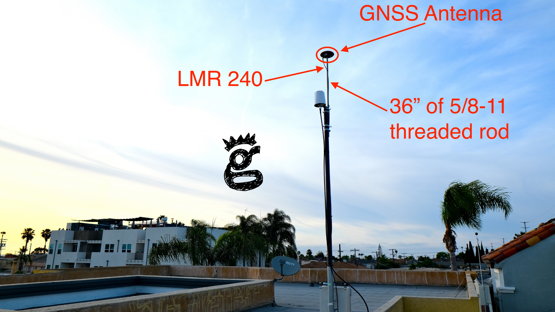
Pull all that out, put it together, then mount it on your roof and you’ve added to what’s called an RTK network, but I’m getting ahead of myself. Let’s start with what my setup looks like, then I’ll walk you through why I did what I did. Yes, it’s on the same pole as a Helium Hotspot.
First, you’ll need access to a roof with a clear view of the sky all around. Buildings, trees, and hills that block that clear view will cause a problem. Want “clear view” defined? Measure an angle from 10º and above in a circle around where you think you’ll deploy this antenna. If there is anything solid in that path above 10º, you don’t have a clear view.
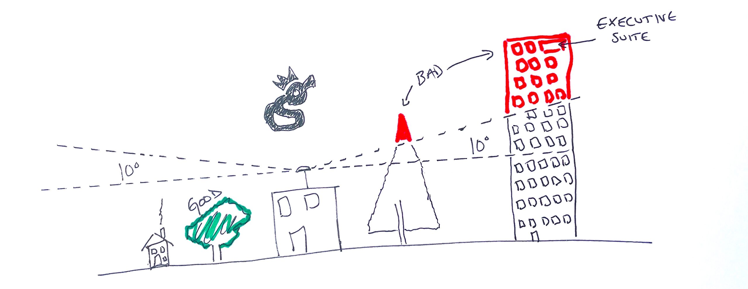
For most of us who’ve deployed Helium miners outdoors, this is pretty easy to accomplish. A standard non-penetrating roof mount with a 10–20′ pole in it, and the antenna mounted at the top of that pole will do the trick. There are, however, a few caveats.
First, due to the accuracy required, GEODNET recommends that your antenna be stable to the millimeter. Yes, that means your antenna shouldn’t move more than a millimeter in any direction when “strong force” is applied. I used a 10′ pole (1.75″ .095 4130 from Competitive Metals in El Cajon) instead of my usual 20′+, with tough plastic wedging the pole into the roof mount base so it wouldn’t move.
Second, if you’re going to pursue “dual mining” (both Helium & GEOD on one pole), I’m recommending a longer mounting bolt than the one GEODNET supplies, which is 12″ long. The longer mounting bolt (I used a 36″ long 5/8–11 from my local Lowe’s, or you can order one from Amazon) gives vertical separation between your Helium antenna (in my case, the HNTenna) and the supplied GNSS antenna. While there’s a low likelihood of interference between the two, I figure for an extra $8 I might as well make a clean install. I attached everything with hose clamps. Love ’em or hate ’em, they sure make things easy.
Third, you may, as I did, need a longer cable than the supplied 10m one to reach from the antenna down to the miner. The supplied cable was labeled “SYV-50–3 Jumper”.
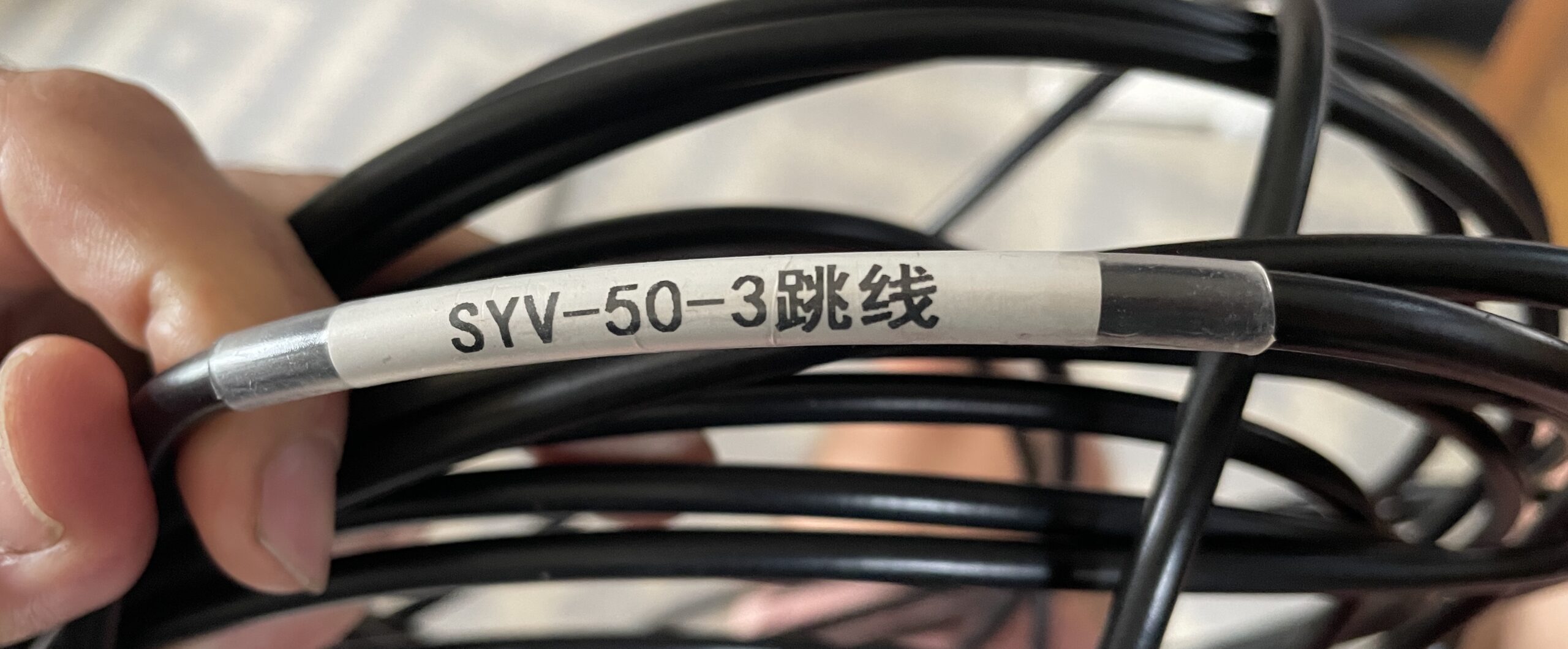
If I’m understanding that correctly, that’s equivalent to RG-58. At the supplied length of 10m (~33′) it would have a loss of 7.2 dB at 1575 MHz, which is the primary frequency used. I cut the cable open just to see what it looked like inside. It had a stranded core, thin insulation, and thin shielding.
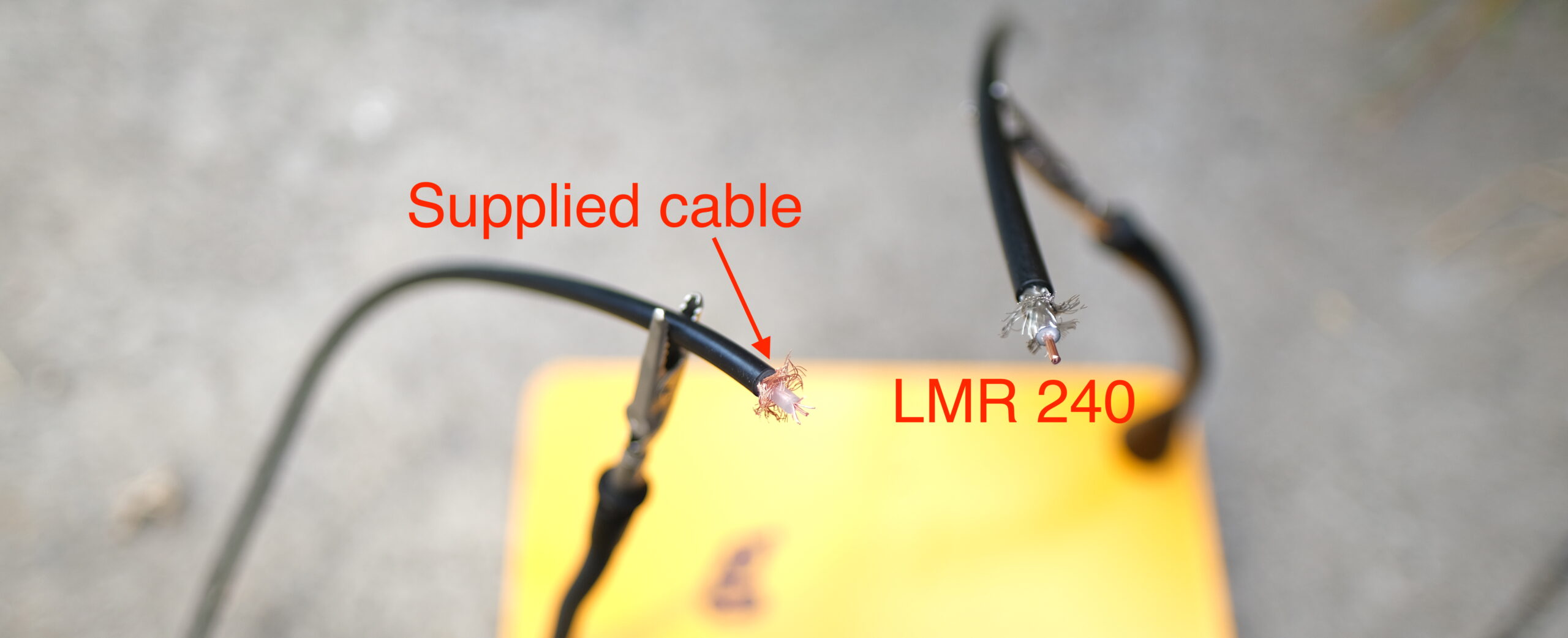
I used LMR240 (just because I had enough of it to make the run) and made a 50′ cable with the appropriate connectors (TNC male and SMA male) for my setup. That introduces ~5.6 dB of loss into the equation if we’re assuming a 1575 MHz frequency. The LMR240 has a solid core, thicker shielding, and thicker insulation. It is stiffer and very slightly thicker. The general takeaway here (thanks @Kartuc on Discord!) is to aim for 6 dB or less of cable loss.
The rest of set up is just running cables and following the directions from GEODNET, which you can find here for the miner.
Then you’ll need to set up your GEODNET account using the “Quick Guide” found on their Discord and add your newly set up miner to your GEODNET account.
Ok, we’ve now got a GEODNET MobileCM™ Base Station set up. Want to know the details of how this thing works and really, what it does? Let’s dive in!
I’m going to introduce some vocabulary that might be new to you (it was to me) that’ll help you understand what this whole thing is, and why it’s useful.
GNSS — Global Navigation Satellite System: This includes many kinds of satellite-based positioning systems.
GPS — Global Positioning System: One type of GNSS,
CORS — Continuously Operating Reference Station
RTK — Real Time Kinematic: A “correction stream” of data coming from an Earthside station to improve the accuracy of GNSS data.
Base Station — A known static Earthside location that receives satellite data, then transmits a correction data stream over the internet.
Rover — Any device that receives GNSS signals from a mobile platform. This is what most of would call “our GPS”.
Here’s the shortest way an engineer would describe this: A GEODNET MobileCM Base Station contributes to a CORS network of RTK base stations improving GNSS accuracy.
Septrentrio has done an excellent job explaining the details of GNSS over here.
The reasonably short version is that the satellites we use for GPS are basically flying clocks that travel known orbits, emitting regular signals. If you remember back to high school math, knowing where and when something is and how fast the signals it emits are traveling, one *should* be able to calculate where you are based on the time it takes to receive those signals. Relax, no one is going to make you DO that math.
However, a few interfering factors like space weather, atmospheric disturbances, and “multi-path” reflection of the satellite signal off buildings or other obstructions can introduce errors to accuracy by changing the signal path from satellite to your receiver,
What you’re doing when you set up a GEODNET is adding a reference point that improves accuracy. It “listens for” (receives) satellite data and reports back through the internet about when it heard that data. This allows for complex calculations to be done that, in essence, say something like:
“Hey, the Gristle King station heard a signal from Satellite XYZ a few seconds late. That probably means there’s something going on with a solar flare or multi-path or atmospheric interference that delayed the signal between Satellite XYZ and the GK station. Let’s go ahead and adjust for that disturbance for any receivers near the Gristle King station.”
Since a fixed point on the ground doesn’t move, having a base station creates a known reference point for calculations made between satellites and receivers elsewhere on the earth.
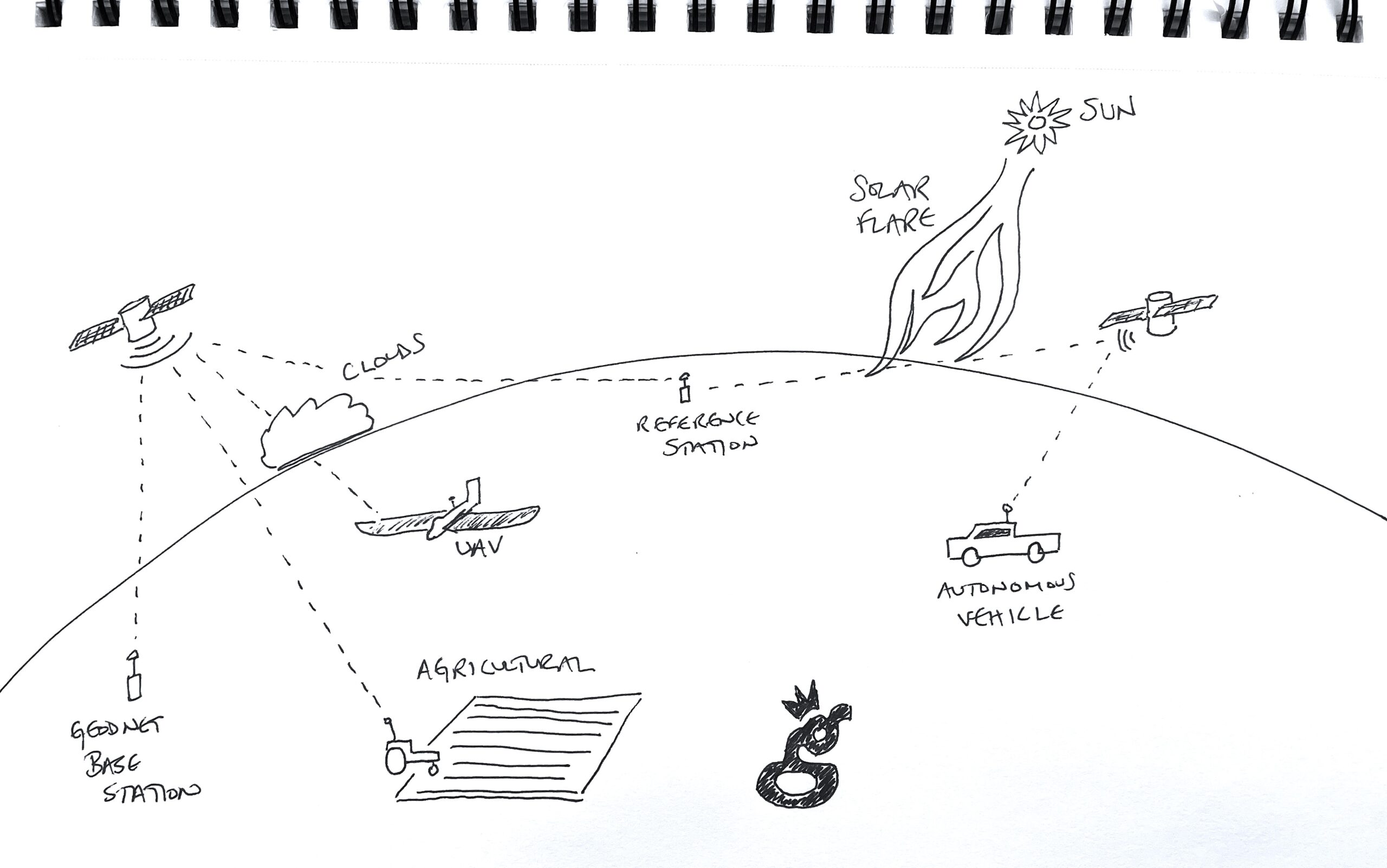
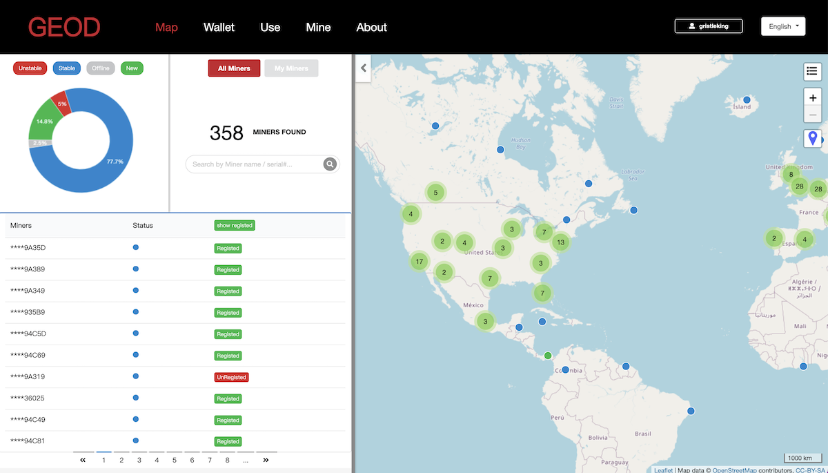
Ideally you’ve got a network of stations all reporting, which allows for the Gristle King station in San Diego to be referenced against stations in nearby towns like La Mesa, or cities like Tijuana or Los Angeles. As we get more stations online, the data gets more and more accurate. Here’s what the map looks like today, May 28th, 2022.
How accurate can you get? With the right setup, and stations approximately 10 km apart, accuracy can be calculated down to the centimeter! That starts to get super useful if you’re planting crops and want to put your seeds in the right place, or you’re doing aerial photography, UAV (drone) navigation, hydrographic surveys, or you just want to know where that scooter is that you’re supposed to be jumping on.
Ok, so all that’s cool, but, uh, how do I get paid?
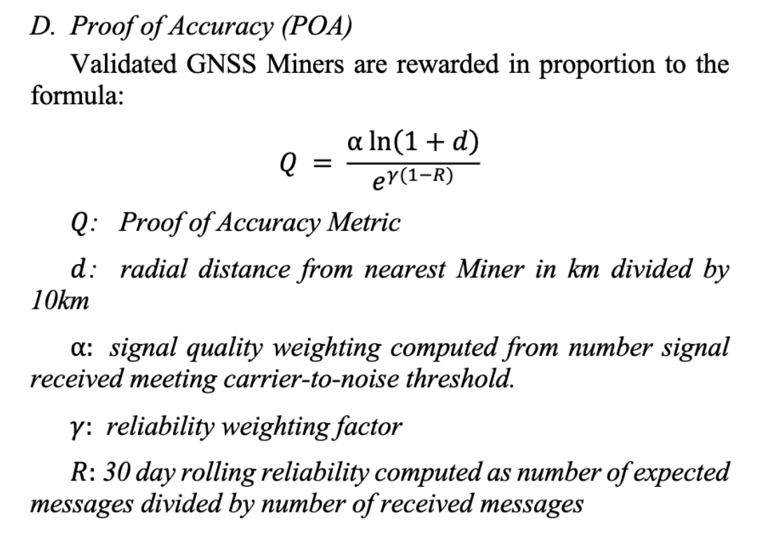
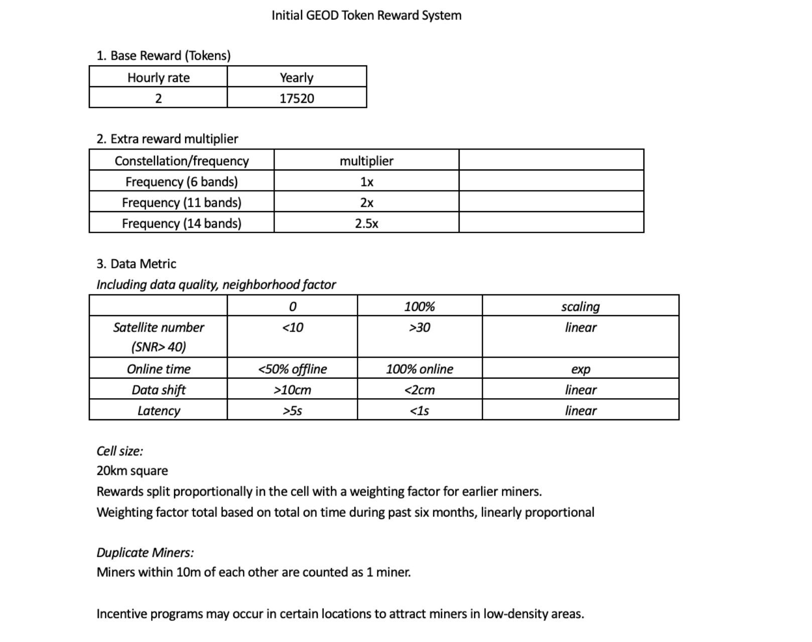
Just like every other wireless blockchain project, you get paid for the data you produce. There is an initial period for early adopters where as long as you have a miner up, you’ll get paid just to keep it online & working. As of late May 2022, all registered stations receive 2 GEODs (the token) per hour. I’m assuming that is higher than we’ll get as more stations join, and at some point we’ll switch over to the white paper equation for Proof of Accuracy (PoA). Payment will then be based on signal quality, the number of signals received, uptime, and the location of your miner.
The total amount of tokens available comes from the token supply equation, which is also in the white paper.
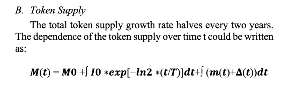
For an in depth explanation of those equations and their variables, check out the white paper. If you’d like a quick overview of the initial GEODNET reward system, take a look at this:
GEOD tokens are currently on Polygon, though they’re aiming to switch to their own blockchain at some point. I’ve been receiving my tokens regularly, though it took a day or two for the flow to start.
Frequently Asked Questions
These are pulled from the AMAs that GEODNET has been doing and a user/ambassador named Rouven has been compiling. Rouven is a volunteer and runs a Facebook group in support of GEODNET. He’s on Twitter & Instagram as well, follow him there if you want to stay up to date. These are NOT my questions nor answers, though I have edited some of them for easier reading.
Location Questions
How will GEODNET avoid/control saturation? If two miners are within 10km, the first miner online and stable will see a higher portion of the rewards. Basically, any miners within 10 km of each other are treated as the same miner splitting rewards. In general, everyone reading this memo (April 15th, 2022) is early and should probably not worry so much unless they are less than 5 km from another station. Even then, being early means rewards levels are high according to halving schedule. A year or so from now, a new entrant comes in very nearby to another station, they can be a bit more concerned. The current “cohort” is very early.
When can I see the 20 km cells on the map? Early May of 2022 was the prediction.
Can I move my miner to a different location? Yes, it will happen automatically if you move, but…be aware when you’re offline, the online metric will be impacted, and if you vacate a spot you lose your seniority at that spot.
Token & Rewards Questions
When will the token be listed on exchanges? The realistic time frame is probably end of 2022.
What is the plan for the voting structure/method of the GeoDAO? Voting power will be proportional to staked tokens. 50% majority for normal decisions, 2/3 majority for big decisions.
Will there be any “protection” for early adopters? Total uptime metric will provide an Advantage to the early adopter who maintains station in a location consistently.
What are estimated rewards per day? This depend on quality of installation, location, up-time and # of satellites seen. A good installation should earn +/-30 tokens per day in year 1, with a halving planned for year 2.
Will the token be on its own blockchain eventually? Yes. It will start on Polygon to make it easier for everyone, but we are working on developing our own blockchain like Helium, with our own proof of location protocol.
Why is there a need for a new blockchain when there are so many fast, “green”, and low fee blockchains? We are developing a new consensus protocol that implements secure, anonymous proof of location. This would be difficult / expensive to implement as a Smart Contract on top of another chain. Furthermore, if we use external blockchain, we will consume a lot of gas to operate the service providers nodes and deploy broad use of the service itself. If we use our own chain, this value instead consolidates back to the GEOD token which is good for the token holders.
Hardware & Setup Questions
Will other antennas (like Helium) cause interference? Helium antennas should not be a problem. Major LTE or TV towers will cause interference, try and keep away from them. [Nik’s comment: The distance to keep away is not defined, though in other Q&A’s they say that cell companies often add GNSS antennas to their own tower. Vertical standoff is probably the best way to manage this.]
What are the maintenance requirements? Minimal, you’ll mostly have problems with local area network or power issues.
What antenna cable should I use? We ship with LMR400 and it is okay to 15m or so (we ship 10m). LMR600 is really the best cables but heavy. Use LMR600 if need for >15m. If using LMR400 cable, the cable could be extended another 30m or more. [Nik’s comment: I did not receive LMR400 with my unit, and I used 50′ of LMR240. I’m not sure how much difference this will make.]
During the winter season, will snow on the antenna influence the satellite accuracy? What about bird poop or dust? You do not need to try to clear the unit off. We have a unit in northern Norway with a lot of snow on it during February, and the signals were still very good. Poop and dust are transparent for RF. If the signal quality really goes down, you will be able to see this on the Console soon and then you could decide to clear the snow. GNSS frequencies are in the 1 – 1.5GHz range which is a long ways from ~2.4GHz where attenuation due to moisture is much bigger issue.
Will these units overheat and shutdown if the temps get too high? Not likely, as it would need to get up in the 70C realm to overheat.
Where I am [local regulations] require bonding & grounding of the antenna. The kit doesn’t come with components to address this. You can add a lightening protector before the MobileCM SMA to protect HYFIX unit from lightening surge if you want. If the building has a ground strap/point then you can add a strap to connect from the TNC of the antennae to the building ground strap.
Can I run one of these off grid? Yes, you’ll need a 4G connection in addition to solar panels and a battery.
Is there a safe limit of wind speed for the antenna to be exposed? How stable does it need to be? There is a global station in Patagonia where the winds are quite regularly 100km/hr. The antennae itself is not impacted by wind, but if you are in a high-wind location secure it extremely well. The general rule of thumb is that the antennae mount can hold your body weight! Millimeters of motion matter, the more secure the better.
What antenna does the GEODNET ship with?
The GEODNET ships with an SK6618 from Shsiki, you can find more on that here. When I got the chance to talk with GEODNET founder Mike, he was confident this was one of the best antennas on the market, and that, unlike Helium, you probably wouldn’t get any noticeable improvement with an upgraded antenna.
Business Development & Use Questions
Will I be able to get some local weather data from my miner in dashboard and maybe a weather prediction? You will be able to visualize your own miners satellite visibility and signals quite quickly (by June). Eventually we can build a bigger picture and you will be able to see regional ground motion (such as plate movements), and the real-time Global Views of the ionosphere, like this one.
What’s are the requirements for becoming a device vendor/maker? Is there a device certification process in place to make new makers entering the market to ad here to certain data/reception/compliance standards? GEODNET is now actively working with a truly third party GNSS maker with no prior relationship to any GEODNET team member. This will pave the way to publish a good independent process, and GEODNET welcomes new miner makers. If there are other interested parties feel free to reach out thru the GEODNET website. We are not ready to openly publish the process yet, but can share it to qualified groups under NDA.
Who are the potential buyers of Geodnet data, and are there any deals already? Yes, we have one deal in place already (Ag oriented supplier Hemisphere GNSS) and in discussion with a 2nd company. We will also likely introduce self-service portal for individual users such as Drone Survey and traditional survey. Potential buyers might come from survey, farming, construction, mapping, autonomous vehicles, IoT applications like eScooter, blockchain apps for anonymous Proof of Location and Proof of Time.
Can the GEODNET base stations provide reference data for private, encrypted, low orbit GNSS satellites like the Xona Pulsar satellites, or is the focus and the hardware limited exclusively on open medium orbit GNSS satellites? We are looking into LEO satellites. [Nik’s note: LEO = Low Earth Orbit]. I will reach out to Xona this week to discuss with them. We know Xona team well, and they have expressed support for GEODNET following its initial presentation in ION 2021. In the future, it would be ideal if GEODNET community can actually operate some Xona or similar LEO satellites to provide more decentralization and capability.
How would the GEOD Network utilize the Helium network as you mentioned a PCI slot for upgrading the miner? GEODNET network can use Helium to send GNSS correction downstream. The GEODNET miners are gathering the Space Weather data, but ultimately that data or a processed variant of the data must be sent to the “Rover/Mobile” GPS/GNSS, as that is the “thing” that needs an accurate position. This is normally done over 4G/LTE or in some cases on a low-data rate satellite channel called L‑band. L‑band is very slow and requires excellent sky visibility. Helium is a good alternative as the data is cheap, and the availability is wide spread. The Helium network would benefit greatly from this use case as GNSS corrections are relatively data intensive compared to many of the simpler LoraWAN applications. Normally it requires 300bits/sec to 1kb/set more or less continuously.
Is any API available to interact with the Geodnet console or to retrieve information about my miner? Not at this time, but we will do it eventually when we have a larger team to handle an API.
Can we host a Global Base and run a miner? [Nik’s note: A Global base is a larger unit and different than a standard GEOD miner.] YES. This is fine and not a bad idea. An RF splitter can be used. We still need more Global Base Locations but not so much in central Europe. Africa, Central America, Central Asia, Northern Japan and Remote Island Locations are highly desired.
How will coordinates of the antenna will be calculated? The coordinates are continuously computed. GNSS stations are used to detect and track coastal tide motion as well as plate tectonic shifts. This is one of their big benefits. If the station is moved this is self-detected; however, it will also negatively impact the stations rewards for a while. So before official mining starts, place your station in a location that is stable and won’t require relocation.
Is the security of the GNSS data in the blockchain guaranteed? Can a nation-state force GEODNET to release the data for your purposes and misuse it or is this secured? This is a tricky and really great question. In short term GEODENT will have a centralized token issuance scheme on Polygon, so I think if the “FBI comes knocking” there is not much we could do but “help”. Later when GEODNET runs its own GEODNET chain … then the network it is more fully decentralized. GEODNET then will be better protected from such potential abuse
That should answer most of your questions. If you want to order a miner you can do so here.
Hit me up in the comments with anything else and I’ll respond or update this post as needed. GEOD on!
Resources
- ORDER A GEODNET base station miner
GEODNET Github Whitepaper - GEODNET Website
- GEODNET Console
- GEODNET Whitepaper Presentation
A quick word on the links in this blog post. Some of them are affiliate links, which will take you to a site that pays me a small commission on sales. There is no extra cost to you, and those commissions help keep the lights on here in Gristle-land.
Leave a Reply