It’s a warm sunny day just west of and about 1,600 feet above Lake Elsinore, at a paragliding launch site unimaginatively called “The E”. A few of us are getting ready to launch off the steep face of the hill to ride thermals and the wind. Our “plan A” today is to see if we can fly a giant triangle in the sky, at least 50 km. Plan A doesn’t happen.
Our plan B, however, is to test small trackers on the Helium network and see just how well they work. Plan B works splendidly.
First, what the heck is paragliding? It’s not parasailing (that’s where you get towed up behind a speedboat in Cancun. You’re basically a sack of suspended meat in the air.
It’s not hang gliding (although that’s equally rad). Paragliding is using something that looks like a parachute to launch off a mountain, hook a thermal going up, ride it to the top, then take off on glide. You repeat the thermal climb and glide cycle as many times as you can find a thermal until you get tired or run out of daylight. The US distance record is over 250 miles. Yep, without an engine. Here’s what paragliders and hang gliders look like. Hang gliders are the triangle shape.
Ok, so what does that have to do with Helium?
Simple: Back up trackers. Most of the time, we free flight pilots (that’s what we call ourselves, whether paragliders or hang gliders) fly in places where we don’t need tracking; places near cities, places where we can pop out at 4 in the afternoon, fly for an hour, and be home in time for dinner.
Sometimes we go a little further, a little deeper in the mountains, where cell coverage is less reliable.
Sometimes we go way out back of beyond, places it’s so empty they don’t even build cell towers (looking at you, Nevada.)
In those empty places, our first option is a GPS tracker, which works well most of the time. Our second option is a cell phone, which works great as long as we’re around cell towers. Which we aren’t always. Our third option is…nothing.
Or at least, it was. That’s where Helium comes in. With a small tracker, something about the size of a handheld radio, we can set up Helium gateways ourselves and track where we’re going over huge distances. That’s important, because some of us (not me) fly huge distances in remote places.
Back in August of 2020, a paraglider I didn’t know named Kiwi flew out into a clear Nevada sky and disappeared.
The free flight community rallied all our resources, and when your community is a combination of ultra-geeky engineers and thrill seekers, you end up calling in global satellite imagery companies, 3 letter government agencies, drone operators, an army of ground-pounding searchers on ATVs, side by sides, mountain bikes, on foot, and a small air force of helicopters, bush planes, sail planes, and stunt planes.
I flew up from San Diego in a friend’s small plane (an RV8 if you must know) to join the search for a couple days. Despite multiple rock ‘n roll flights in mid-day mid-summer low-level thermic conditions, we didn’t find him.
It took us (the paragliding community) 30 days to find him. We were far too late; he was dead when he hit the ground.
He had been using GPS and a cell phone for tracking. With very few cell towers in the area of Nevada he was flying, cell reception wasn’t good. When he hit the ground, he smashed his GPS, which was on his front side. He didn’t have a “tertiary geolocation option.” None of us did. We all thought two was enough. Kiwi’s disappearance taught us it wasn’t.
So that brings us to how I found Helium. I wanted a tracker that would work as a backup option. Something you could throw in the back of your harness and forget about. I stumbled on LoRa, got side tracked into this whole cryptocurrency application, and set out to see if I could use Helium to track paragliders.
The short version? You can.
Using a company out of Texas to provide the trackers and the visualization, I bought a few Oyster trackers and handed them out to local paragliders. I had set up a Helium gateway at one of our local sites, so I was pretty sure it would work there, and it did.
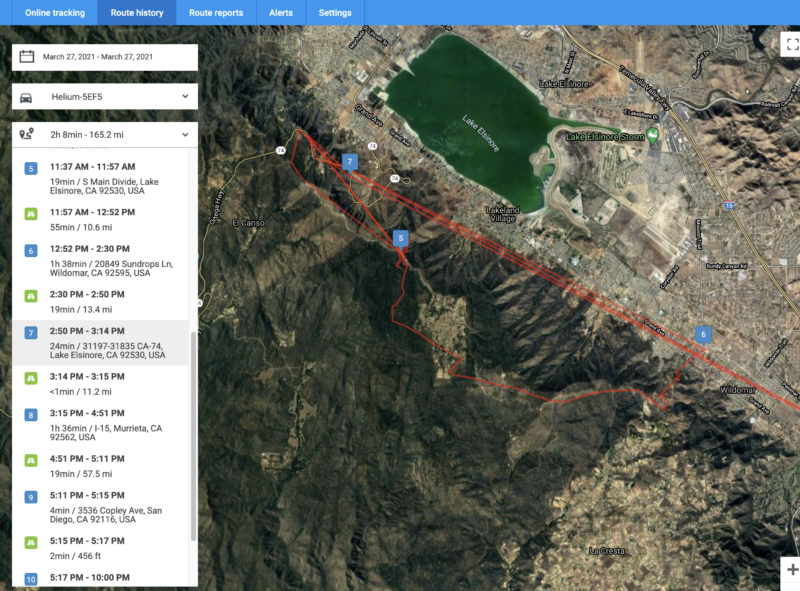
What I was curious about was the next step: Would it work where I hadn’t set up a gateway optimized for tracking pilots? Yep, it does. In the image above, that’s my flight on March 21st, 2021, taking off at The E and landing about 5 miles down range to the south east. Not an exceptional flight by paragliding standards, but enough to show that with a few local Helium hotspots scattered around, you can track paragliders.
I don’t own or control any of the stations providing coverage around that area. They’re all set up, run, and maintained by other people. That’s one of the many very cool aspects of the Helium network. You don’t HAVE to set up your own gateway in order to use trackers (or any other sensor.)
What does the tracker look like? Here’s a picture of it on my gear, right before I unpacked and took off to fly the other day. Yep, it’s that little white plastic thing.
Now, what happens when you don’t have any hotspots close by, and you’re flying over a valley surrounded by hills and mountains. Can you still be tracked?
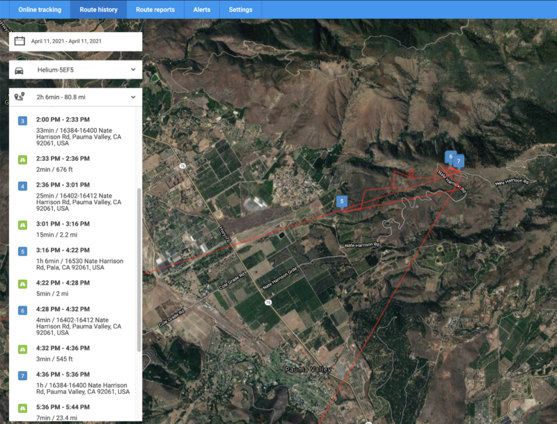
Yep. That one is an even shorter flight, but it’s from a different launch site (Palomar) where no hotspots are nearby. Doesn’t matter. LoRa takes small packets of information LONG distances (the Lo in LoRa). The nearest active hotspot is almost 40 km away, and on the far side of a mountain range!
Update to this: The Palomar mountain range now has many Hotspots deployed on it, and turned out to be a profit-generating machine when it came to Helium deployments in 2021.
In the picture below, the green spots are active Helium hotspots, also known as “gateways”. Those are the things that are receiving information from sensors, then pass it on to the Helium Network where it’s processed by companies like Lonestar.
Ok, ok, enough hype. What are the limitations?
- As you can see in the LoneStar tracking image, tracking stops when I go below the line of the mountain range, at point 5. Radio waves don’t go through mountains. Sometimes around, never through.
- The tracking wasn’t set up for a fast time interval, so the track is jagged.
- As of right now, you can’t turn the trackers off, so when I drive home, everyone with my tracking link can see where my house is.
- If you don’t have cell coverage, you can’t connect to the internet, so you need to put the gateways where they’ll have cell coverage.
None of those are insurmountable. It’s pretty easy to fit an on/off switch to the thing (Travis Teague could do it at 3 AM with his eyes closed in between polyphasic sleep cycles). You can set a faster interval, although you’ll drive battery life down from years to months, and maybe days if you set it to 1 second intervals. You can set up a geofence around a “do not track” area. Finally, even in out-back-of-beyond Nevada you can find cell towers in odd places and create tracking coverage. That’s going down the rabbit hole of link budget and bandwidth a little, and it’s not absolutely perfect, but it sure is nice to have that tertiary tracking option.
What about placing hotspots?
Here’s an image from the aforementioned Teague of a remote-deployable temporary hotspot (aka gateway aka miner). Let’s say you’re setting up an adventure race, or a way-out-there mountain bike 200 mile loop where you want to see where all your riders are. Hell, maybe you want another crack at the Nevada state distance record on a paraglider.
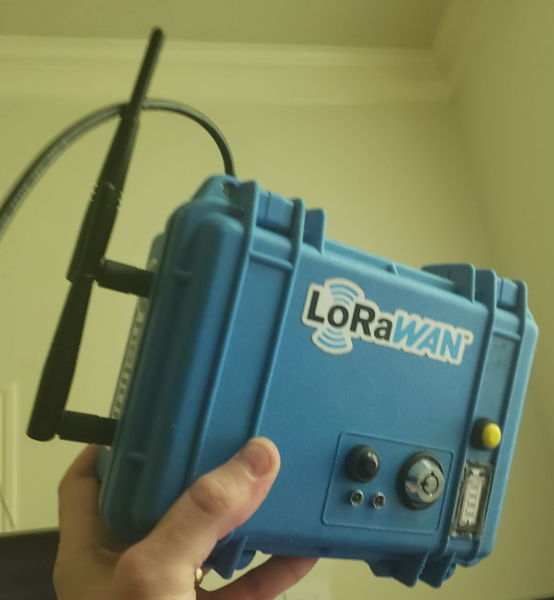
It’s not as easy as pushing a button; you’ll have to go place that little hotspot on a mountain top somewhere, but it ain’t that hard, either. You could bring a hotspot up to launch and leave it there until everyone is landed and accounted for. Find a few high mountains with trails up to ’em and you’ve got a fun project for the part of your team that likes that kind of Type II fun.
The thing will run for a few days on a battery, so you don’t have to come back right away. Add a solar panel and you could leave it up there for a season.
Helium, both hotspots and trackers, provides that tertiary geolocation option I was wishing Kiwi had back in August.
In this case, the application isn’t a super sexy fancy tracker that will link to Twitter and your old Myspace account plus your new TikTok account (although I bet someone will figure that out).
It IS, on the other hand, a rugged little long-lifed sucker that’ll cost you less than satellite tracking stations or cell towers to set up (by a LOT), will be fun to deploy (depending on your idea of fun) and may be the difference between you being found by nightfall or found at month’s end when you’re out at the limits of human performance.
So, what will YOU do with Helium?
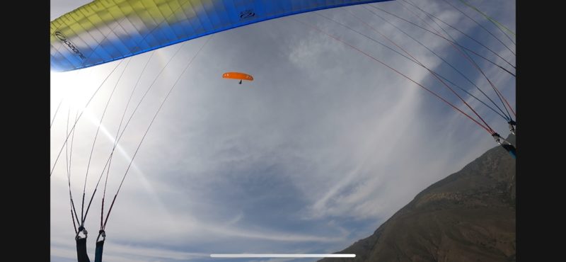
See ya in the sky! Yeah, that’s me in the orange wing on a lovely Sunday afternoon out at Palomar.
Want to know more about trackers and Helium and the magic of blockchain + radio?
Resources
- Lonestar Tracking
- Helium
- Yabby Trackers (not mentioned in the article, but pretty cool)
- Guppy Trackers (same, not mentioned but pretty cool)
- Jump on Discord and say hi, I’m @gristleking
Leave a Reply